Evidence #233 | August 31, 2021
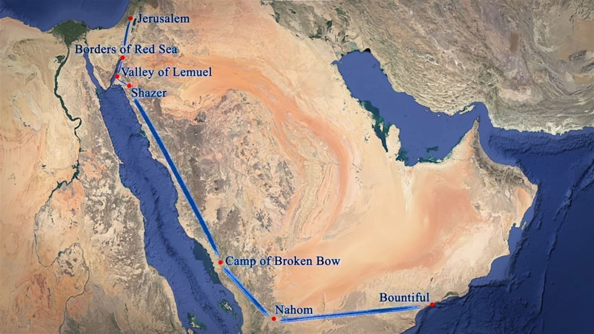
Overview of Lehi’s Journey
Post contributed by
Scripture Central
Abstract
Various lines of data help connect Lehi’s trail with the known geography of ancient Arabia, creating a comprehensive and persuasive convergence of evidence.The Book of Mormon begins with a prophet named Lehi who was commanded by God to lead his family out of Jerusalem and into the wilderness around 600 BC (1 Nephi 2:2). The account of their journey through the Arabian Peninsula has now been thoroughly studied using a variety of disciplines, including archaeology, geography, history, anthropology, and literary studies.
Within this large body of work, several lines of evidence have been uncovered which support the Book of Mormon’s claims of being an authentic ancient record. While these lines of evidence are discussed separately in individual evidence articles, they are presented here collectively to illustrate their cumulative weight and mutually reinforcing relationships.
Jerusalem’s Elevation
In describing their journey from Jerusalem into the wilderness, Lehi’s son Nephi consistently said they traveled “down” to the wilderness (e.g., 1 Nephi 2:5). In contrast, journeys from the wilderness back to Jerusalem are repeatedly described as going “up” (e.g., 1 Nephi 3:9). This is consistent with common Hebrew and Egyptian idiom for traveling to and from Jerusalem in antiquity.1 In addition to emphasizing the elevated and holy status of Jerusalem’s temple, this idiom also reflects real-world topography: Jerusalem is built on a prominent hill that is noticeably elevated above surrounding wilderness regions. Thus, the wording in the text subtly and accurately reflects the topography of Jerusalem and its environs.
Jerusalem to the Red Sea
After fleeing from Jerusalem, Lehi led his family down by the Red Sea (1 Nephi 2:1–5). Evidence from ar chaeology, inscriptions, and biblical texts confirms that there were trade connections between Judah and Arabia around 600 BC.2 This means that established roads traversing the southern Judean desert would have provided access to the Red Sea in Lehi’s day, something that cannot always be assumed or taken for granted in the ancient world.
The exact road Lehi and his family followed cannot be known with certainty, but scholars have documented at least five different routes connecting Jerusalem to the branch of the Red Sea known today as the Gulf of Aqaba.3 Lehi’s likely professional background in metallurgy may even suggest that he personally had commercial ties in that area, since well-known copper mines were located there in antiquity.4 Lehi’s initial flight into the wilderness and toward Arabia and the Red Sea is therefore plausible and consistent with what is known about this region around the 7th–6th century BC.
The Frankincense Trail
The main commodity exported from Arabia into the rest of the ancient Near East and Mediterranean was aromatics, most especially frankincense. For this reason, scholars today commonly refer to the main trade route running through the Arabian Peninsula as the “Frankincense Trail” or the “Incense Road.” Frankincense was harvested from Dhofar in Oman and the valleys of Hadramawt in Yemen. From these regions it was shipped westward through the major kingdoms of ancient South Arabia, and then northward parallel to the Red Sea.5 While the exact path taken by travelers could vary somewhat, the topography of Arabia channeled all major traffic along this general course, as it was the only route available with traversable terrain and regular access to food, water, and other vital resources.
Based on Nephi’s account, Lehi’s journey appears to follow this general outline in the reverse direction—his party began at the northern end of the Red Sea (1 Nephi 2:5), traveled “south-southeast” for an extended length of time (1 Nephi 16:13–14, 33), and then turned “nearly eastward” (1 Nephi 17:4). While he and his family may not have strictly stuck to this trail every step of the way, it appears that they followed it closely.
The existence of a trail that generally mirrors Lehi’s route adds to the plausibility of Nephi’s account, since it means the family would have had regular access to necessary resources, most especially food and water, at various intervals along their journey.
The Valley of Lemuel
After arriving at the Red Sea, most likely at the northern end of the Gulf of Aqaba, Lehi’s family continued to travel another three days, at which point they set up camp by a “continually running” river which “emptied into the fountain of the Red Sea” (1 Nephi 2:9). This river ran through a valley (named after Lehi’s son, Lemuel) that was “firm and steadfast, and immovable” (v. 10). While they stayed there, the family gathered seeds from a variety of grains and fruits (1 Nephi 8:1).
Travelers on long journeys in the ancient Near East typically covered 15–25 miles per day on average.6 This means that the Valley of Lemuel should likely be located approximately 45–75 miles down the coast of the Gulf of Aqaba. Impressively, the only known valley with a river or stream that perennially flows towards the Red Sea in all of northwestern Arabia is Wadi Tayyib al-Ism, a 74-mile trek from the northern end of the Gulf of Aqaba.7 Sheer 2000-foot granite cliffs flank the western end of the valley. It also features wild grain, dates, and berries, from which seeds could have been harvested.8
According to a recent hydrological assessment, “The Arabian Peninsula is the largest area on Earth that has almost no natural perennial river.”9 Thus, it is truly remarkable that one can be found within the limited area required by the Book of Mormon text, and that it flows through a valley that is consistent with Nephi’s description of the Valley of Lemuel.
Shazer
The next stop after the Valley of Lemuel was a place that Lehi’s family called “Shazer” (1 Nephi 16:12–14). To get to Shazer, the family had to travel “nearly a south-southeast direction” for four days—which at a 15–25 mile per day pace would be about 60–100 miles. At Shazer, they successfully hunted, indicating that it was located in an area with game nearby. The likely meaning of the name Shazer also suggests it was a good hunting area, and possibly a place with many trees.10
Assuming their starting point was Wadi Tayyib al-Ism, the location within 60–100 miles that best fits the limited description of Shazer is Wadi Agharr (also called Wadi esh-Sharma).11 Wadi Agharr is a 70-mile journey from Wadi Tayyib al-Ism in a generally south-southeast direction. A southeast-trending wadi leading out of Tayyib al-Ism would allow Lehi’s traveling party to head directly toward Agharr without backtracking, consistent with the directions given in Nephi’s account. Locals familiar with the area have reported that the mountains around Wadi Agharr provide some of the best hunting grounds in the region.
Thus, although the information on Shazer is limited, what we do know or can infer from the text correlates well with an identifiable, real-world location.
From Shazer to Nahom
The distance from Shazer to Nahom is unspecified in the text, but Nephi repeatedly mentioned “many days” of travel in between (1 Nephi 16:15, 17, 33), suggesting it was the longest stretch of their journey. They departed Shazer “following the same direction” as before, and maintained “nearly the same course” throughout (vv. 14, 33), so they generally continued in a south-southeast course during this stretch of their travels. As they departed Shazer, they started “in the borders near the Red Sea” (v. 15) but apparently distanced themselves from the seacoast going forward as they traveled through “most fertile parts” and “more fertile parts” before reaching a more barren region (vv. 14, 16). In this area, Nephi’s steel bow broke, and he made a new one out of wood (vv. 18–23).
An ancient and medieval trail that runs in a generally south-southeast direction passes straight through Wadi Agharr and continues through the Hijaz mountains which border the Red Sea coastline, eventually merging with the main Frankincense Trail.12 As one travels in generally the same course southeastward along the Incense Road, the fertility levels decline until reaching an especially barren area of southern Saudi Arabia. Despite the lack of fertility along the trail in that region, suitable bow-making wood can be found up in the mountains.13
Thus, while Nephi does not provide extensive details, what he does say is consistent with what can be found along this section of the Frankincense Trail in antiquity.
Nahom
After this extended journey south-southeast, the next place mentioned by Nephi is called “Nahom,” and unlike all the other locations mentioned, this is not a name explicitly given by Lehi’s family; rather it was “the place which was called Nahom” (1 Nephi 16:34), suggesting it existed before Lehi and his family arrived. As such, this place could potentially be mentioned—and therefore verified—in other historical sources. Nephi’s father-in-law, Ishmael, was buried at Nahom, and then they departed “nearly eastward” (1 Nephi 17:1).
The main course of the Frankincense Trail runs predominantly north-south parallel to the Red Sea until reaching the Wadi Jawf in Yemen, where the trail then trends more east-west, connecting the South Arabian kingdoms with the frankincense-growing regions to the east. In modern times, the region bordering the Wadi Jawf to the south is known as the Nihm (sometimes spelled Nehem, Naham, etc.) district, named after the Nihm tribe. Evidence from early Islamic sources shows that this tribe has been in this same general region since before the rise of Islam, and the Nihm (or Naham, Nehem, etc.) name has been applied to their territory for much of its documented history.14
Most significantly, a number of ancient inscriptions, some dating to around the time of Lehi, have been discovered in Yemen referring to nhmyn, which scholars typically translate as “Nihmite,” meaning a person from the tribe or region of Nihm (NHM).15 Based on these ancient inscriptions, scholars have located the Nihm tribe in the region bordering the Wadi Jawf going back to the 7th century BC.16 Extensive burial grounds have been found in and near the Nihm region.17
Thus, a place with a name similar to “Nahom” (Nihm or Nehem, Naham, etc.) does exist in Yemen, and ancient inscriptions indicate that it existed in Lehi’s day as well. Since ancient Egyptian and Hebrew, along with the ancient inscriptions from Yemen, do not include vowels, Nahom could reasonably be another variant spelling of this same name. Nihm is located next to the Wadi Jawf, where the Frankincense Trail turned eastward, as Lehi did after Nahom (1 Nephi 17:1), and there are burial grounds where Ishmael could have been buried.
Travel Eastward from Nahom
As mentioned, the main course of the Frankincense Trail closely mirrors Lehi’s journey. Among the most salient correlations between the two routes is the turn eastward. Due to the inhospitable desert and lava fields covering most of Arabia, east-west travel across most of the peninsula was essentially impossible in antiquity. Some off-shoots from the main trail broke out toward the northeast at various points along the way, but truly east-west oriented travel only became possible south of Najran.
At this point, the main trail began to veer in a more easterly direction around the Wadi Jawf, moving in an “eastward arc” through Marib, Timna, and Shabwah, the capitals of the ancient kingdoms of Saba, Qataban, and Hadramawt. Eventually trails cutting across the desert more directly eastward allowed travelers to go straight from the Wadi Jawf to Shabwah.
Thus, eastward travel across Arabia only became possible in the vicinity of the Wadi Jawf, near where the Nihm tribal territory was located. This is where the main branches of the Frankincense Trail began to veer east, consistent with the eastward turn described in Nephi’s account in association with Nahom.
Bountiful
Traveling “nearly eastward” from Nahom, Lehi’s family arrived at a place along the southern coast of Arabia, which they named “Bountiful,” due to “its much fruit and also wild honey” (1 Nephi 17:5). Based on explicit and implicit criteria derived from Nephi’s account, this place possessed access to fresh water, wildlife (1 Nephi 17:11; 18:6), ore (1 Nephi 17:10, 16), a prominent mountain peak (1 Nephi 17:7; 18:3), cliffs along the shore (1 Nephi 17:48), access to timber (1 Nephi 18:1) and several other features.
Nearly due east from Wadi Jawf and the Nihm tribal area is the region of Dhofar, in Oman, one of the main centers of frankincense cultivation in antiquity. This green and lush region of fertility stands in stark contrast to the arid landscape that makes up the rest Arabia’s southeastern coastline. All the features of Bountiful have been documented in this area. Two inlets in particular—Khor Kharfot and Khor Rori—appear to fit well with Nephi’s description of Bountiful in the Book of Mormon.18
Conclusion
Each of the correlations discussed above holds some evidentiary value on its own, although some are stronger than others. None, however, can be fully appreciated when considered in isolation. They must be looked at collectively to see their full significance.
Jerusalem’s commercial ties to Arabia and the general course of the Frankincense Trail illustrate that people and goods were moving back and forth between Jerusalem and South Arabia in antiquity, and doing so according to the same directions of travel as Lehi. Thus, Lehi’s journey is consistent with the actual travels of real people in the ancient world. Moreover, the subtle and topographically accurate descriptions of going “down” into the wilderness, and “up” to Jerusalem reinforces the likelihood that the author had actually been to and traveled these ancient roads.
At the northern end of the trail, the locations of the Valley of Lemuel and Shazer form a tight, interconnected relationship, thanks to the precise number of days traveled and directional statements provided by Nephi. Both needed to be located within a relatively narrow geographical range, and in fairly close proximity to each other along a north-northwest/south-southeast axis. Some of the details relative to these locations are exceptional and unique for this region—especially the perennially flowing stream at Wadi Tayyib al-Ism.
On the southern end of the trail, a location with an NHM name and other corroborating details needed to be in an east-west relationship with a fertile coastal location that matches all the details of Nephi’s Bountiful, some of which are, once again, quite exceptional for the region.
The link between the northern and southern ends of the trail is also important. The network of Nahom-eastward trail-Bountiful area needed to be in Southern Arabia, linked to the northern network of Jerusalem-Valley of Lemuel-Shazer by a long, but traversable route that generally ran in a south-southeast direction. Not only does the main branch of the Frankincense Trail form just such a link, but the various details mentioned as part of the intervening journey are consistent with the real world found along the Frankincense Trail.
Furthermore, it is remarkable that the north-south and east-west portions of both the Frankincense Trail and Lehi’s journey were connected by an eastward turn at a location with an NHM name. Thus, Nahom is much more than just a name in the text that is corroborated by ancient inscriptions. It is an attested name given in conjunction with a prominent directional shift in travel that connects the major portions of Lehi’s journey. It can be seen as a linchpin, allowing independently impressive lines of evidence to converge together into a much stronger cohesive argument.
Together, this coalescence of data persuasively links Lehi’s trail with the known geography and customs of ancient Arabia. Individually, many of these details would have been unknown or most likely inaccessible to Joseph Smith in 1829. Thus, when viewed collectively, they provide powerful evidence of the authenticity of Nephi’s account and of Joseph Smith’s prophetic calling.
As mentioned previously, more detailed explanations of each of these lines of evidence can be found in the individual evidence articles linked throughout this summary, as well as in the sources cited throughout those articles and in their further reading sections.
Book of Mormon Evidence: Jerusalem’s Elevation
Book of Mormon Evidence: Jerusalem to the Red Sea
Book of Mormon Evidence: The Frankincense Trail
Book of Mormon Evidence: The Valley of Lemuel
Book of Mormon Evidence: Shazer
Book of Mormon Evidence: From Shazer to Nahom
Book of Mormon Evidence: Nahom
Book of Mormon Central: Travel Eastward from Nahom
Book of Mormon Evidence: Bountiful
- 1 See Hugh Nibley, Lehi in the Desert/The World of the Jaredites/There Were Jaredites (Salt Lake City and Provo, UT: Deseret Book and FARMS, 1988), 7.
- 2 See André Lemaire, “New Perspectives on the Trade between Judah and South Arabia,” in New Inscriptions and Seals Relating to the Biblical World, ed. Meir Lubetski and Edith Lubetski (Atlanta, GA: Society of Biblical Literature, 2012), 93–110; Pieter Gert van der Veen and Francois Bron, “Arabian and Arabizing Epigraphic Finds from the Iron Age Southern Levant,” in Unearthing the Wilderness: Studies on the History and Archaeology of the Negev and Edom in the Iron Age, ed. Juan Manuel Tebes (Walpole, MA: Peeters, 2014), 203–226.
- 3 Most of these routes are described and mapped in S. Kent Brown, “Jerusalem Connections to Arabia,” in Glimpses of Lehi’s Jerusalem, ed. John W. Welch, David Rolph Seely, and Jo Ann H. Seely (Provo, Utah: FARMS, 2004), 626–629.
- 4 Jeffrey R. Chadwick, “Lehi’s House at Jerusalem and the Land of his Inheritance,” in Glimpses of Lehi’s Jerusalem, 113–117.
- 5 For background on the Arabian incense trade in antiquity, see Nigel Groom, Frankincense and Myrrh: A Study of the Arabian Frankincense Trade (New York, NY: Longman, 1981); Shimshon Ben-Yehoshua, Carole Borowitz, and Lumír Ondrej Hanuš, “Frankincense, Myrrh, and Balm of Gilead: Ancient Spices of Southern Arabia and Judea,” in Horticultural Reviews 39, no. 1 (2012): 1–76.
- 6 Michael C. Astour, “Overland Trade Routes in Ancient Western Asia,” in Civilizations in the Ancient Near East, ed. Jack M. Sasson (New York, NY: Charles Scribner & Sons, 1995), 1403 estimates that daily stages along the caravan routes in the Levant averaged 15–20 miles. For caravan routes in Arabia, Groom, Frankincense and Myrrh, 211 estimates that they averaged a pace of 20–25 miles per day. Alessandro de Maigret, “The Frankincense Road from Najran to Ma‘an: A Hypothetical Itinerary,” in Profumi d’Arabia: Atti del Convegno, ed. Alessandra Avanzini (Rome: L'Erma di Bretschneider, 1997), 325 argues for an even faster pace of 40–50 kilometers (ca. 25–31 miles) per day, on average. This might be reasonable for experienced travelers and caravaneers who were used to long, arduous days of travel, but unlikely for a family used to living in the city, such as Lehi’s.
- 7 Mohammed Abdullah Alsaleh, “Natural Springs in Northwest Saudi Arabia,” Arabian Journal of Geosciences 10, no. 335 (2017), identified 9 perennial springs in northwest Arabia; of those, only two—Wadi Tayyib al-Ism and Ain Musa—were near the coast of the Gulf of Aqaba; between these two, only Wadi Tayyib al-Ism had a regularly flowing stream.
- 8 See George D. Potter, “A New Candidate in Arabia for the Valley of Lemuel,” Journal of Book of Mormon Studies 8, no. 1 (1999): 54–63; Warren P. Aston, “Into Arabia: Lehi and Sariah’s Escape from Jerusalem,” BYU Studies Quarterly 58, no. 4 (2019): 99–126.
- 9 Max Engel, Helmut Bruckner, and Karoline Messenzehl, “Natural Environment of the Arabian Peninsula,” in Roads of Arabia: The Archaeological Treasures of Saudi Arabia, ed. Ute Franke and Joachim Gierlichs (Berlin: Museum of Islamic Art, 2011), 44.
- 10 See Matthew L. Bowen, “Shazer: An Etymological Proposal in Narrative Context,” Interpreter: A Journal of Latter-day Saint Faith and Scholarship 33 (2019): 1–12.
- 11 See George Potter and Richard Wellington, Lehi in the Wilderness: 81 New, Documented Evidences That the Book of Mormon is a True History (Springville, UT: Cedar Fort, 2003), 73–78; Warren P. Aston, “Nephi’s ‘Shazer’: The Fourth Arabian Pillar of the Book of Mormon,” Interpreter: A Journal of Latter-day Saint Faith and Scholarship 39 (2020): 61–69.
- 12 Abdullah al-Wohaibi, “The Northern Hijaz in the Writings of the Arab Geographers, 800–1150” (Phd diss.; University of London, 1969), 36, 377–391; Groom, Frankincense and Myrrh, 206, 260n47.
- 13 See Potter and Wellington, Lehi in the Wilderness, 73–106.
- 14 See Warren P. Aston, “The Origins of the Nihm Tribe of Yemen: A Window into Arabia’s Past,” Journal of Arabian Studies 4, no. 1 (2014): 139. For an example of it being used as a toponym more than 1000 years ago, see D. M. Dunlop, “Sources of Gold and Silver in Islam According to al-Hamdānī (10th Century AD),” Studia Islamica 8 (1957): 41.
- 15 Christian Robin and Burkhard Vogt, eds., Yémen: au pays de la reine de Saba’ (Paris: Flammarion, 1997), 144; Jacques Ryckmans, Walter W. Müller, and Yusuf M. Abdallah, Textes du Yémen Antique Inscrits Sur Bois (Leuven: Institut Orientaliste, Université Catholique de Louvain, 1994), 46–50, pl. 3A–B.
- 16 John Simpson, ed., Queen of Sheba: Treasures from Ancient Yemen (London: The British Museum, 2002), 166–167; Peter Stein, Die altsüdarabischen Minuskelinschriften auf Holzstäbchen aus der Bayerischen Staatsbibliothek in München, 2 vols. (Tübingen and Berlin: Ernst Wasmuth Verlag, 2010), 1:22n.43, 23.
- 17 Alessandro de Maigret, Arabia Felix: An Exploration of the Archaeological History of Yemen (London: Stacy International, 2009), 329, 338–339.
- 18 See Warren P. Aston, “The Arabian Bountiful Discovered? Evidence for Nephi’s Bountiful,” Journal of Book of Mormon Studies 7, no. 1 (1998): 4–11, 70; Richard Wellington and George Potter, “Lehi’s Trail: From the Valley of Lemuel to Nephi’s Harbor,” Journal of Book of Mormon Studies 15, no. 2 (2006): 35–43.
© 2024 Scripture Central: A Non-Profit Organization. All rights reserved. Registered 501(c)(3). EIN: 20-5294264