Evidence #93 | September 19, 2020
Highways
Post contributed by
Scripture Central
Abstract
In several ways, the highways discussed in the Book of Mormon are similar in form and function to highways constructed in ancient Mesoamerica.Expansive systems of highways were constructed by several ancient American societies,1 and their remains have long been studied by archaeologists.2 The ancient Maya, in particular, built and used highways “from the Late Formative through the Postclassic periods” (ca. 400 BC–AD 1500) in a manner that fits descriptions of highways found in the Book of Mormon.3
“Many Highways”
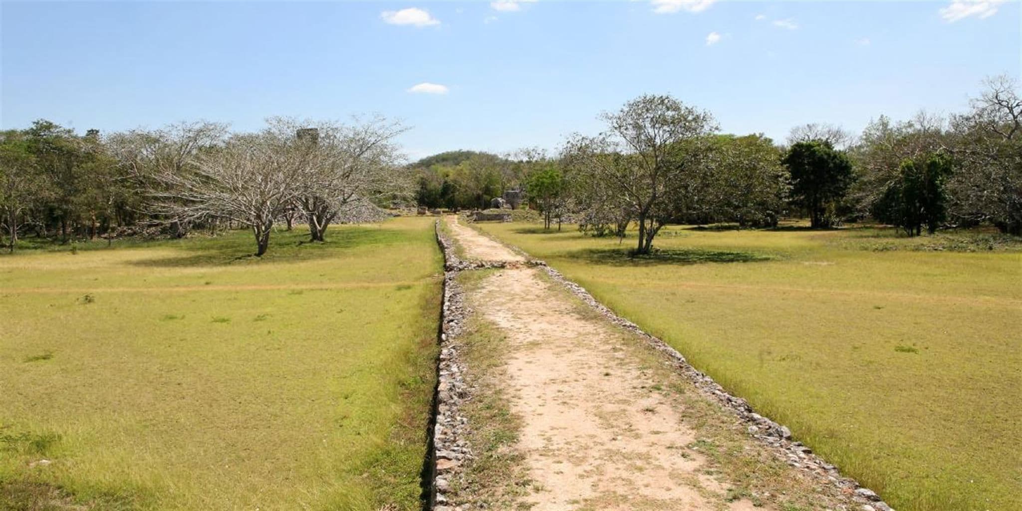
The Book of Mormon mentions that during a period of peace “there were many highways cast up, and many roads made” (3 Nephi 6:8; emphasis added). Ancient Mesoamerica featured vast networks of highways that cumulatively extended for hundreds of miles.4 Major sites had dozens of such roads. For instance, more than 80 of them have been documented at Chichen Itza alone.5 In addition, recent data from an aerial laser technology called LiDAR has allowed researchers to identity many more highways hidden beneath the dense jungle.6
“Cast Up”
The description of highways being “cast up” (3 Nephi 6:8) indicates that many roads in the Book of Mormon were more than just well-worn paths. Human construction was involved to raise them above ground level, similar to the “cast up” roads of ancient Israel (see Isaiah 57:14–15; 62:10).7
Highways in Mesoamerica were likewise elevated. For instance, anthropologist John L. Sorenson commented that the “66 feet (20 m) wide and up to 7 feet (2 m) high” road at Dzibilchaltun in the lowland Maya area involved “massive construction [that] surely qualifies as ‘cast up’.”8 Concerning Mesoamerican highways, Mark Wright has explained:
Although they varied in height and width, their construction was generally composed of rubble lined with large stones at the edges and large cobblestones in the interior, progressively getting smaller from bottom to top, finally gradating to fine gravel near the surface and topped with fine powdered limestone (called sascab), which was pressed smooth with stone rollers.9
“The Highway Which Led to the Chief Market”
Ancient Maya highways often connected major districts or building complexes within their sprawling cities. Metropolises like El Mirador had numerous causeways that branched out from the city, somewhat like spokes on a wheel.10 In many cities, at least one major road led to what researchers believe were central market plazas.11 The “highway which led to the chief market” near Nephi’s garden tower is consistent with this commonly proposed architectural layout for ancient Maya cities (Helaman 7:10).
“City to City,” “Land to Land,” and “Place to Place”
Anthropologist Justine M. Shaw has proposed that highways among the ancient Maya naturally fit into three categories, which she labeled as (1) “local intrasite,” (2) “core–outlier intrasite,” and (3) “intersite.” As explained by Shaw,
The first, referred to here as “local intrasite,” connects major architectural groups within and immediately around the site core. … The second category, “core–outlier intrasite,” runs 1 to 5 km to connect the core with more distant portions of the site, such as outlying groups. … The final proposed category is the ‘intersite’ sacbeob, which connect spatially distinct sites that are at least 5 km apart.12
Mormon similarly assigned highways into three categories, describing them as leading from (1) “city to city,” and (2) “land to land,” and (3) “place to place” (3 Nephi 6:8). This possibly suggests that highways in both ancient Mesoamerica and in the Book of Mormon may have been grouped into three separate tiers, perhaps based on distance and other factors.13
Straight Paths
According to Shaw, “Nearly all Maya causeways are straight” and “even when features of moderate size lie in the projected path of a sacbe, every effort is made to maintain the same line, even to the point of covering earlier constructions.”14 Alma’s message to the people of Gideon stressed the importance of making the Lord’s “paths straight” because the Lord “cannot walk in crooked paths” (Alma 7:19–20).15 While Alma’s language and imagery is biblical,16 his message would have been especially impactful in a Mesoamerican setting—where people went out of their way to literally make paths straight.
Conclusion
At this time, no ancient American highways or roads can be definitively linked to Book of Mormon peoples. Yet, as summarized above, several features of ancient Mesoamerican highways are consistent with the highways described in the Book of Mormon. The significance of these parallels is increased by the fact that in 1829, when the Book of Mormon was translated, most Americans likely didn’t know or expect that native civilizations had anciently built such extensive systems of transportation.17
Book of Mormon Central, “Is There Evidence for Book of Mormon Highways in Ancient America? (3 Nephi 6:8),” KnoWhy 470 (September 25, 2018).
Mark Alan Wright, “The Cultural Tapestry of Mesoamerica,” Journal of the Book of Mormon and Other Restoration Scripture 22, no. 2 (2013): 4–21.
John L. Sorenson, Mormon’s Codex: An Ancient American Book (Salt Lake City and Provo, UT: Deseret Book and Neal A. Maxwell Institute for Religious Scholarship, 2013), 356–357.
Alma 7:20Helaman 7:10 Helaman 14:24 3 Nephi 6:8 3 Nephi 8:13- 1 See Justine M. Shaw, “Maya Sacbeob: Form and Function,” Ancient Mesoamerica 12 (2001): 268.
- 2 For instance, see Alfonso Villa Rojas, “The Yaxuna-Cobá Causeway,” Contributions to American Archaeology 2, no. 9 (1934).
- 3 Shaw, “Maya Sacbeob: Form and Function,” 268.
- 4 See John L. Sorenson, Mormon’s Codex: An Ancient American Book (Salt Lake City and Provo, UT: Deseret Book and Neal A. Maxwell Institute for Religious Scholarship, 2013), 356–357: “Roads were made and used for at least 2,500 years before the Spanish conquest, beginning with the Olmec people at San Lorenzo. Hundreds of miles of them have now been discovered in locations ranging from the state of Zacatecas on the north to Yucatan and Atlantic Guatemala on the south.”
- 5 See Francisco Pérez Ruiz, “Recintos amurallados: Una interpretación sobre el sistema defensivo de Chichen Itza, Yucatán,” in XVIII simposio de investigaciones arqueológicas en Guatemala, 2004, ed. Juan Pedro Laporte, Bárbara Arroyo, and Héctor E. Mejía (Guatemala City: Museo Nacional de Arqueología y Etnología), 882–883. For an English version of this publication, see Francisco Pérez Ruiz, “Walled Compounds: An Interpretation of the Defensive system at Chichen Itza, Yucatan,” online at famsi.org.
- 6 See also, Brigit Katz, “LiDAR Scans Reveal Maya Civilization’s Sophisticated Network of Roads,” February 3, 2017, online at smithsonianmag.com; Tom Clynes, “Exclusive: Laser Scans Reveal Maya ‘Megalopolis’ Below Guatemalan Jungle,” February 1, 2018, online at news.nationalgeographic.com.
- 7 The Hebrew term for “highway” (masillah) literally means “raised road.”
- 8 Sorenson, Mormon’s Codex, 357.
- 9 Mark Alan Wright, “The Cultural Tapestry of Mesoamerica,” Journal of the Book of Mormon and Other Restoration Scripture 22, no. 2 (2013): 14. In connection with the smooth surface of these highways, see 3 Nephi 8:13: “And the highways were broken up, and the level roads were spoiled, and many smooth places became rough” (emphasis added).
- 10 See Wright, “The Cultural Tapestry of Mesoamerica,” 14.
- 11 See, for example, Bruce H. Dahlin, Daniel Bair, Tim Beach, Matthew Moriarty, and Richard Terry, “The Dirt on Food: Ancient Feasts and Markets Among the Lowland Maya,” in Pre-Columbian Foodways: Interdisciplinary Approaches to Food, Culture, and Markets in Ancient Mesoamerica, ed. John Edward Staller and Michael Carrasco (New York, NY: Springer, 2009), 220. Of the fifteen lowland Maya marketplaces tentatively identified in this study, “All of them are accessible by sacbeob [highways] or other transportation networks” and all but two of them “have paved surfaces” (p. 220).
- 12 Shaw, “Maya Sacbeob: Form and Function,” 262.
- 13 As explained by Shaw, her “proposed groupings appear to have been a reality for the Lowland Maya. Although I do not insist that the Maya themselves would have classified Sacbeob in this manner, and I realize that the measurements and sample are a product of archaeologists’ foci, the divisions are apparently related to something in the real world. The groups are possibly related to the distance normally walked by site inhabitants in a day, the length easily traversed by participants in a ritual, or the span over which political control may have been exerted and maintained under certain conditions.” Shaw, “Maya Sacbeob,” 266. Support for the idea that the Nephites at least used of one of these categories (a day’s journey) comes from Helaman 4:7: “And there they did fortify against the Lamanites, from the west sea, even unto the east; it being a day’s journey for a Nephite, on the line which they had fortified and stationed their armies to defend their north country” (emphasis added).
- 14 Justine M. Shaw, “Roads to Ruins: The Role of Sacbeob in Ancient Maya Society,” in Highways, Byways, and Road Systems in the Pre-Modern World, ed. Susan E. Alcock, John Bodel, and Richard J. A. Talbert (Chichester, UK: John Wiley & Sons, 2012), 137.
- 15 This passage is interesting because it is the only symbolic path in the Book of Mormon that is certainly described as being “straight” (meaning not crooked) instead of “strait” (meaning narrow). All other instances of “strai[gh]t” paths are more ambiguous, even though some of them could also mean “not crooked.” See Paul Y. Hoskisson, “Straightening Things Out: The Use of Strait and Straight in the Book of Mormon,” Journal of Book of Mormon Studies 12, no. 2 (2003): 62; Book of Mormon Central, “Is the Path to Eternal Life ‘Strait’ or ‘Straight’? (1 Nephi 8:20),” KnoWhy 456 (August 7, 2018).
- 16 See, for example, 1 Samuel 6:12; Psalm 5:8; Isaiah 40:3-4; Jeremiah 31:9; Matthew 3:3; Hebrews 12:13. See also, Book of Mormon Central, “Why Does Alma Mention Three Kinds of Paths in One Verse? (Alma 7:19),” KnoWhy 114 (June 3, 2016).
- 17 It is probable that the first reports of ancient American highways were brought to the attention of the general American public by John Lloyed Stephens and Frederick Catherwood more than 10 years after the publication of the Book of Mormon. Among the many roads discussed in his travels, Stephens mentioned “a great paved way, made of pure white stone, called in the Maya language Sacbé, leading from Kabah to Uxmal, on which the lords of those places sent messengers to and fro, bearing letters written on the leaves and bark of trees.” John L. Stephens, Incidents of Travel in Yucatan, 2 vols. (New York, NY: Harper and Brothers, 1843), 1:415. See also, John E. Clark, Wade Ardern, and Matthew Roper, “Debating the Foundations of Mormonism: The Book of Mormon and Archaeology,” 2005 FairMormon conference presentation, online at fairmormon.org.
© 2024 Scripture Central: A Non-Profit Organization. All rights reserved. Registered 501(c)(3). EIN: 20-5294264