KnoWhy #130 | August 20, 2020
Why Did Mormon Give So Many Details About Geography?
Post contributed by
Scripture Central
“And now, it was only the distance of a day and a half’s journey for a Nephite, on the line between the land Bountiful and the land Desolation, from the east to the west sea; and thus the land of Nephi and the land of Zarahemla were nearly surrounded by water, there being a small neck of land between the land northward and the land southward” Alma 22:32
The Know1
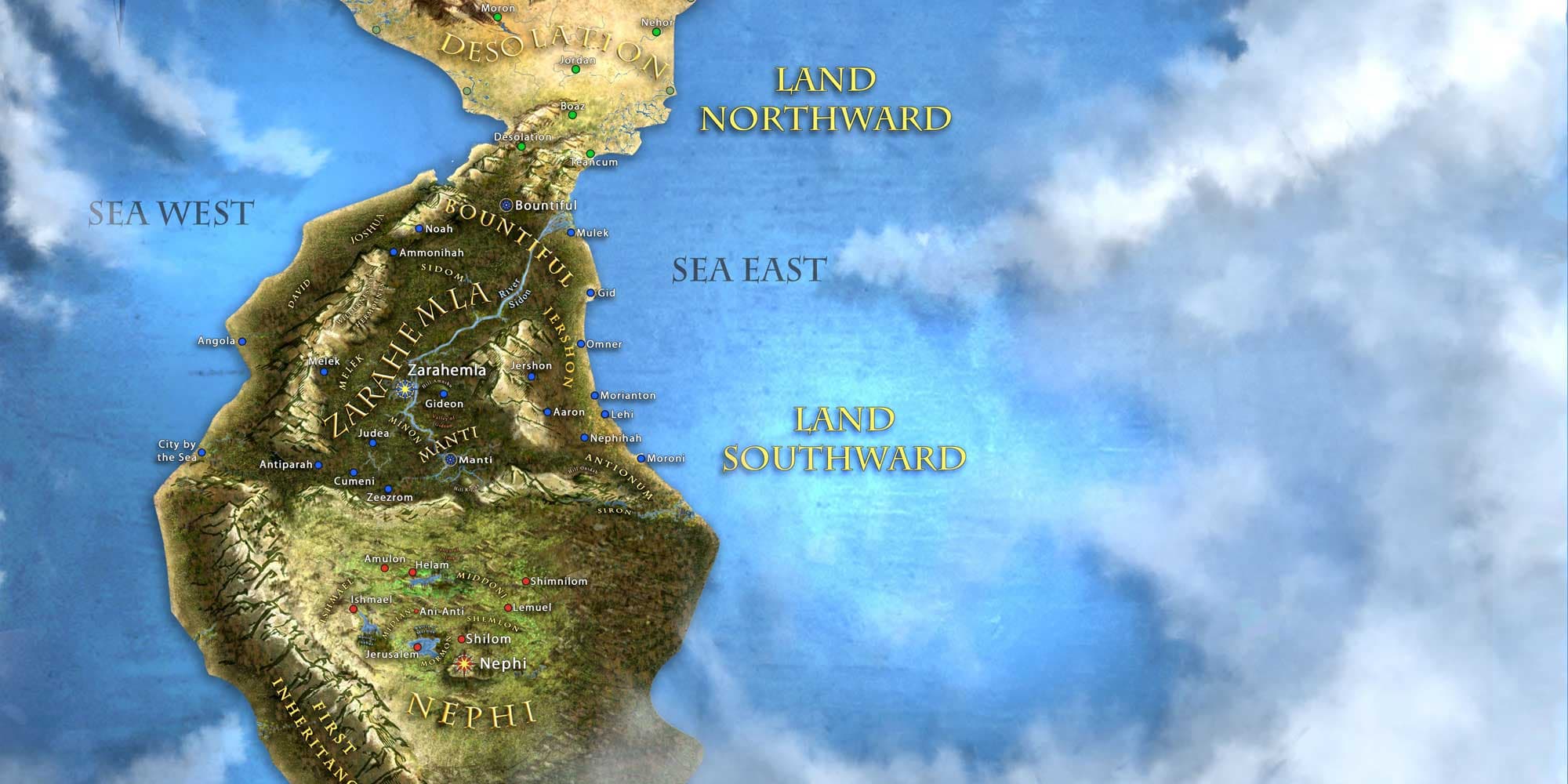
Practically since the Book of Mormon was published, its geography has been the subject of discussion and debate.2 John L. Sorenson, one of the foremost students on the subject, identified over 600 passages relevant to geography.3 Cross-referencing Sorenson’s list with that of John E. Clark,4 Randall Spackman determined that there are upwards of 1000 passages of potential geographic significance.5
Both Sorenson and Clark used hundreds of these passages to develop an internal reconstruction of Book of Mormon geography.6 They mapped out the general lay of the land, and the relationship between different lands and cities without tying it to any real-world location.
Theirs are two among many internal maps which, while having some differences, demonstrate the general geographic consistency found throughout the Book of Mormon.7
Amidst the hundreds of passages, Alma 22:27–34 is widely understood to be the most comprehensive statement available on the configuration of Book of Mormon lands. Sorenson explained:
The nearest thing to a systematic explanation of Mormon’s geographical picture is given in Alma 22:27–34. In the course of relating an incident involving Nephite missionaries and the great king over the Lamanites, Mormon inserted a 570-word aside that summarized major features of the land southward. He must have considered that treatment full and clear enough for his purposes, because he never returned to the topic.8

Due to this, Alma 22:27–34 is highly discussed by Book of Mormon geographers.9 Mormon gives readers over a dozen points of geographical information,10 as shown in the table below.
What lay farther to the north, beyond Desolation, or farther to the south, past the land of Nephi, is left unsaid. Peoples of Lehite descent likely migrated in both directions during and after Book of Mormon times. As a result, descendants of Lehi may be found throughout the Americas,11 even though the events in the Book of Mormon played out in a more limited sphere.12
The Why
After disrupting the narrative with this “geography word map,” as archaeologist V. Garth Norman has called it,13 Mormon said, “And now I, after having said this, return again to the account of Ammon and Aaron, Omner and Himni, and their brethren” (Alma 22:35). It is clear from this that Mormon knew he had interrupted the narrative flow. Given the limited space, and careful way Mormon crafted his text, he must have had good reasons for inserting these details, along with the hundreds of other references to geography found throughout the text.
One likely reason is that Mormon, who was both a historian and military leader, knew how important geography is to understanding historical events, especially military history. All the many hundreds of geographic details scattered throughout the text can get confusing. There had already begun to be some movements back and forth between the different lands: battles, dissentions, and migrations. Mormon was aware that there were about to be several more, including his detailed accounts of troop movements and battle strategies during the great seven years of war in Alma 43–62.
Amidst this dizzying array of details, the text’s demonstrable geographic consistency shines forth as a powerful witness to the sophistication and complexity of the Book of Mormon.14 Upon careful inspection, Grant Hardy, a professor of history, has found, “It requires considerable patience to work out all the details of chronology, geography, genealogy, and source records, but the Book of Mormon is remarkably consistent on all of this.”15 From this observation, Hardy concluded:

The complexity is such that one would assume the author worked from charts and maps, though Joseph Smith’s wife—the person who had the longest and closest view of the production of the text—explicitly denied that he had written something out beforehand that he either had memorized or consulted as he translated.16
Mormon probably knew how confusing all the many details were getting. He realized that without some kind of broader picture of Nephite lands, ensuing narratives about missionary travels, commercial relationships, political divisions, and prophetic fulfillments would be difficult, if not impossible, to follow. As V. Garth Norman noted, “Mormon gave very specific geographic details at times … that could have no other purpose than to paint the landscape where these events occurred.”17
All this geographical information not only adds another layer of complexity, but also strengthens the sense that the text describes a true historical reality. As John L. Sorenson pointed out in 2002, “Inconsistencies that might be expected of a fraudulent work … are notably absent in the Book of Mormon.”18 On the other hand, “It seems unlikely that this consistency could have been obtained unless the author(s) had directly experienced some particular real-world setting, not an imaginary place.”19
As a youthful traveler, long-time military leader, and trusted steward over a library of sacred records, Mormon certainly had intimate and direct experience with the landscape and information about it. Despite the destructions reported in 3 Nephi 8–9, he knew and recognized many of the lands, rivers, valleys, mountains, waters, and seas mentioned in his historical sources. Having worked on this record with his father, Moroni also went out of his way to testify that their record is true and that they “lie not” (Moroni 10:26).
This was a land that Mormon knew, and no doubt a land that he loved, and a land which he was pained to see swept away in so much warfare, sin, and violence (Mormon 2:11–15). In Alma 22:27–34, and in the many other geographic details running throughout, Mormon and the other authors give today’s readers accurate glimpses of a promised land tragically lost.
Table of Geographic Features
| Alma 22:27–34 | Geographic Feature |
|---|---|
| “the land northward” (v. 32) | A land northward |
| “the land southward” (v. 32) | A land southward |
| “there being a small neck of land between the land northward and the land southward” (v. 32) | A small neck of land, between the north and the south |
| “the sea west” boarding Nephi (v. 27); “west of the land of Zarahemla, in the borders by the seashore” (v. 28); “the west sea” by Desolation (v. 32) | A sea along the western coast |
| “the sea east” (v. 27), “east by the seashore” (v. 29) | A sea along the eastern coast |
| “on the west in the land of Nephi, in the place of their fathers’ first inheritance, and thus bordering along by the seashore” (v. 28) | The land of first inheritance, in the west of the land of Nephi, by the seashore |
| “wilderness which was on the north” of Nephi was “by the land of Zarahemla” (v. 27) | Land of Nephi, to the south of Zarahemla |
| “divided from the land of Zarahemla by a narrow strip of wilderness, which ran from the sea east even to the sea west, and round about on the borders of the seashore” (v. 27) | A narrow strip of wilderness, running east-west from sea-to-sea, divides the lands of Nephi and Zarahemla from each other |
| “the wilderness which was on the north by the land of Zarahemla, through the borders of Manti” (v. 27) | Manti in the south of the land of Zarahemla, near the narrow strip of wilderness |
| “the borders of Manti, by the head of the river Sidon” (v. 27); “the wilderness, at the head of the river Sidon, from the east to the west” (v. 29) | Head of the river Sidon by Manti, in or near the narrow strip of wilderness |
| “on the north, even until they came to the land which they called Bountiful” (v. 29); “it being so far northward that it came into the land which had been peopled and had been destroyed” (v. 30)20 | Bountiful is the northernmost part of the land southward |
| “it bordered upon the land which they called Desolation” (v. 30); “the land on the northward was called Desolation, and the land on the southward was called Bountiful” (v. 31); “the line between the land Bountiful and the land Desolation” (v. 32) | Bountiful bordered Desolation, which was in the land northward |
| “it was only the distance of a day and a half’s journey for a Nephite, on the line between the land Bountiful and the land Desolation, from the east to the west sea” (v. 32) | At least part of the boundary between Bountiful and Desolation was measured as 1.5 days’ travel21 |
| “the land of Nephi and the land of Zarahemla were nearly surrounded by water” (v. 32) | The entire land southward (both the land of Zarahemla and the land of Nephi) was almost completely surrounded by water |
| “had hemmed in the Lamanites on the south, that thereby they should have no more possession on the north” (v. 33); “the Lamanites could have no more possessions only in the land of Nephi, and the wilderness round about” (v. 34) | The Nephites controlled the northern part of the land southward (Manti, Zarahemla, and Bountiful), while the Lamanites controlled the southern part of the land southward |
Dennis L. Largey, et al., “Geography,” in Book of Mormon Reference Companion, ed. Dennis L. Largey (Salt Lake City, UT: Deseret Book, 2003), 288–291.
John E. Clark, “Book of Mormon Geography,” in Encyclopedia of Mormonism, 4 vols., ed. Daniel H. Ludlow (New York, NY: Macmillan Publishing, 1992), 176–179.
- 1. Alma 22:32 as referenced above utilizes Royal Skousen, ed., The Book of Mormon: The Earliest Text (New Haven, CT: Yale University Press, 2009), 362. This is an emendation to the text, justified in Royal Skousen, Analysis of Textual Variants, Part 4: Alma 21–55 (Provo, UT: FARMS, 2007), 2067–2070.
- 2. For overviews on the history of Book of Mormon geography, see John L. Sorenson, The Geography of Book of Mormon Events: A Source Book, revised edition (Provo, UT: FARMS, 1992), 7–35; Matthew Roper, “Limited Geography and the Book of Mormon: Historical Antecedents and Early Interpretations,” FARMS Review 16, no. 2 (2004): 225–276; V. Garth Norman, Book of Mormon–Mesoamerican Geography: History Study Map (American Fork, UT: ARCON, Inc./Ancient America Foundation, 2008), 17–19; Joseph L. Allen and Blake J. Allen, Exploring the Lands of the Book of Mormon, revised edition (American Fork, UT: Covenant Communications, 2011), 371–399.
- 3. John L. Sorenson, Mormon’s Map (Provo, UT: FARMS, 2000), 9: “Overall, over 550 verses in the Book of Mormon contain information of geographical significance: the account is steeped with information about the where of Nephite events.” However, John L. Sorenson, Mormon’s Codex: An Ancient American Book (Salt Lake City and Provo, UT: Deseret Book and Neal A. Maxwell Institute for Religious Scholarship, 2013), 17, 119 places the number as 600. For an annotated listing of every passage Sorenson deemed geographically relevant, see Sorenson, Geography of Book of Mormon Events, 215–315.
- 4. John E. Clark, “A Key for Evaluating Nephite Geography,” Review of Books on the Book of Mormon 1 (1989): 20–70; updated as John E. Clark, “Revisiting ‘A Key for Evaluating Book of Mormon Geographies’,” Mormon Studies Review 23, no. 1 (2011): 13–43.
- 5. Randall P. Spackman, “Interpreting Book of Mormon Geography,” FARMS Review 15, no. 1 (2003): 29.
- 6. Spackman, “Interpreting Book of Mormon Geography,” 26–27, counts 637–725 references used by Sorenson and 318 by Clark.
- 7. Compare Sorenson, Mormon’s Map, inside front cover, with Clark, “Revisiting, ‘A Key’,” 38, fig. 6; also see Sorenson, Geography of Book of Mormon Events, 49–50, 80, 103, 104, 121, 123, 125, 148, 173, 190, 202 for serval other internal reconstructions. A digital, interactive internal map is currently (2016) under development by a team led by Tyler Griffin, Taylor Halverson, and Seth Holladay, which is also broadly consistent with these other maps.
- 8. Sorenson, Mormon’s Map, 9.
- 9. There are 31 references to Alma 22 in Sorenson, Mormon’s Map; 18 in Clark, “Key for Evaluating Nephite Geography.” Speaking of Sorenson and Clark, Spackman, “Interpreting Book of Mormon Geography,” 26 stated: “Both authors begin with Alma 22 and quickly build interpretative links to other passages of text.” Also see Norman, Book of Mormon–Mesoamerican Geography, 3–5; Allen and Allen, Exploring the Lands, 402–416, 422–426; Jonathan Neville, The Lost City Zarahemla: From Iowa to Guatemala—and Back Again (Rochester, NY: Legends Library, 2015), 273–310; Jonathan Neville, Moroni’s America: The North American Setting for the Book of Mormon (Digital Legend, 2015), 25–32; 285–320; Gregory L. Smith, “‘From the Sea East Even to the Sea West’: Thoughts on a Proposed Book of Mormon Chiasm Describing Geography in Alma 22:27,” Interpreter: A Journal of Mormon Scripture 19 (2016): 355–382.
- 10. Textual accuracy is crucial when trying to determine the specifics of Book of Mormon geography. For analysis of all potential variants in Alma 22:27–34, see Skousen, Analysis of Textual Variants, 2057–2072.
- 11. For evidence of travel and trade to and from different regions of the Americas, see John L. Sorenson, “Mesoamericans in Pre-Spanish South America,” in Reexploring the Book of Mormon: A Decade of New Research, ed. John W. Welch (Salt Lake City and Provo, UT: Deseret Book and FARMS, 1992), 215–217; John L. Sorenson, “Mesoamericans in Pre-Columbian North America,” in Reexploring, 218–220. Also see Robert L. Hall, “Some Commonalities Linking North America and Mesoamerica,” in The Oxford Handbook of North American Archaeology, ed. Timothy R. Pauketat (New York, NY: Oxford University Press, 2012), 52–63. On Book of Mormon peoples leaving the core Nephite/Lamanite centers and reaching other regions of the Americas, see Mark Alan Wright, “Heartland as Hinterland: The Mesoamerican Core and North American Periphery of Book of Mormon Geography,” Interpreter: A Journal of Mormon Scripture 13 (2015): 111–129 (for a Mesoamerica migration to North America point of view); Neville, Moroni’s America, 325–352 (for a North America migration to Mesoamerica point of view).
- 12. On the limited size of Book of Mormon lands, see Sorenson, Mormon’s Map, 55–81.
- 13. Norman, Book of Mormon–Mesoamerican Geography, 5.
- 14. See John L. Sorenson, “How Could Joseph Smith Write So Accurately about Ancient American Civilization?” in Echoes and Evidences of the Book of Mormon, ed. Donald W. Parry, Daniel C. Peterson, and John W. Welch (Provo, UT: 2002), 267–269.
- 15. Grant Hardy, Understanding the Book of Mormon: A Reader’s Guide (New York: Oxford University Press, 2010), 6–7.
- 16. Hardy, Understanding the Book of Mormon, 7. On the production process according to Emma and other eye-witnesses, see Neal Rappleye, “‘Idle and Slothful Strange Stories’: Book of Mormon Origins and the Historical Record,” Interpreter: A Journal of Mormon Scripture 20 (2016): 29–32; Michael Hubbard Mackay and Gerrit J. Dirkmaat, “Firsthand Witness Accounts of the Translation Process,” in The Coming Forth of the Book of Mormon: A Marvelous Work and a Wonder, ed. Dennis L. Largey, Andrew H. Hedges, John Hilton III, Kerry Hull (Salt Lake City and Provo, UT: Desert Book and Religious Studies Center, Brigham Young University, 2015), 61–79; Daniel C. Peterson, “A Response: What the Manuscripts and the Eyewitnesses Tell Us about the Translation of the Book of Mormon,” in Uncovering the Original Text of the Book of Mormon: History and Findings of the Critical Text Project, ed. M. Gerald Bradford and Alison V.P. Coutts (Provo, UT: FARMS, 2002), 67–71; Daniel C. Peterson, “Editor’s Introduction—Not So Easily Dismissed: Some Facts for Which Counterexplanations of the Book of Mormon Will Need to Account,” FARMS Review 17, no. 2 (2005): xi–xxiv, xxx–xxxii. All 202 accounts from eye-witnesses and others are included in John W. Welch, “The Miraculous Translation of the Book of Mormon,” in Opening the Heavens: Accounts of Divine Manifestations, 1820–1844, ed. John W. Welch (Provo, UT: BYU Studies, 2005), 118–213.
- 17. Norman, Book of Mormon–Mesoamerican Geography, iix.
- 18. Sorenson, “How Could Joseph Smith Write So Accurately,” 267. Also see John L. Sorenson, Images of Ancient America: Visualizing Book of Mormon Life (Provo, UT: FARMS, 1998), 188: “The consistency cannot be accounted for in terms of Joseph Smith, for his translation of the volume was dictated at such a pace and published with so little revision of content that he could not have accurately crafted the picture of spatial relations involved in the complex story.”
- 19. Sorenson, Mormon’s Codex, 17, cf. p. 119: “This consistency of information indicates that the author’s had firsthand experience of a specific physical scene.” He also made this same point in Sorenson, Images of Ancient America, 188: “The internal consistency of the geographical statements in the Book of Mormon … must be accounted for by assuming the primary author … had a definite mental map in mind.”
- 20. Skousen, ed., The Earliest Text, 362.
- 21. There is some disagreement as to what this may actually mean. For some of the discussion, see Clark, “Revisiting ‘A Key’,” 18; Sorenson, Mormon’s Codex, 122–123; Allen and Allen, Exploring the Lands, 411–413; Neville, Moroni’s America, 57–59; John L. Sorenson, An Ancient American Setting for the Book of Mormon (Salt Lake City and Provo, UT: FARMS, 1985), 17; F. Richard Hauck, Deciphering the Geography of the Book of Mormon (Salt Lake City, UT: Deseret Book, 1988), 34–40; Matthew Roper, “Travel across the ‘Narrow Neck of Land,’” Insights: A Window on the Ancient World 20, no. 5 (2000): 2; John L. Sorenson, “A Day and a Half’s Journey for a Nephite,” in Reexploring, 187–188.