Evidence #121 | November 28, 2020
Book of Mormon Evidence: Valley of Lemuel
Post contributed by
Scripture Central
Abstract
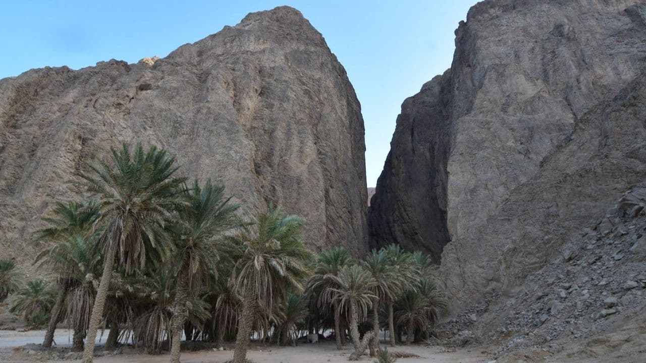
The description of the Valley of Lemuel found in 1 Nephi corresponds well with a river-valley in northwest Arabia called Wadi Tayyib al-Ism.Wadi Tayyib al-Ism
After fleeing from Jerusalem, Lehi and his family set up their first long-term camp “in a valley by the side of a river of water” (1 Nephi 2:6). Upon reaching the site, Lehi poetically compared his two oldest sons to the impressive scene, naming the river after Laman and the valley after Lemuel (vv. 8–10, 14).1 Hence this location is known as the “Valley of Lemuel.”

Past researchers have identified several possible real-world candidates for this site,2 but today most scholars agree that the best option is a river valley called Wadi Tayyib al-Ism, discovered in 1995 by Latter-day Saint explorers George Potter and Craig Thorsted.3 The following summaries highlight the correspondences between the two valleys, based on analysis of Nephi’s account (see Appendix).
A Three-day Journey

Nephi mentioned that after fleeing Jerusalem, his family traveled to the “borders near the shore of the Red Sea” (1 Nephi 2:5). This location most likely corresponds to modern-day Aqaba, which sits at the northernmost tip of the Red Sea’s northeastern channel. It is the first portion of the Red Sea that travelers would likely encounter when heading south from Jerusalem, as Lehi’s family did. After reaching this region, Lehi “traveled three days in the wilderness” before setting up camp (1 Nephi 2:6; emphasis added). Verse 5 further specifies that they “traveled in the wilderness in the borders which are nearer the Red Sea” (emphasis added).
Any plausible candidate for the Valley of Lemuel would therefore need to be approximately a three-day journey south of Aqaba, using a route near the Red Sea.4 Daily travel in the Arabian deserts in antiquity typically ranged between 15–25 miles per day.5 Wadi Tayyib al-Ism sits at the edge of the Red Sea and is 74 miles south of Aqaba, falling just within the maximum distance of a three-day journey (45–75 miles).6
A “Continually Running” River
Lehi described the River Laman as a “continually running” source of water (1 Nephi 2:9). Many of the dry riverbeds in northwest Arabia briefly overflow with water during the rainy season, but perennially flowing water is rare.7 The stream that cuts through sheer granite cliffs at Wadi Tayyib al-Ism, however, has been documented to flow throughout the year, even during the dry season.8

While it can turn into a raging river after heavy rainfall,9 the water flow currently produces only a small stream throughout most of the year. This may partially be due to its water being reallocated to more populated areas in recent years.10 Some accounts from antiquity suggest that northwest Arabia was wetter anciently,11 and geological evidence indicates that the stream once had a stronger, more river-like waterflow.12 Readers should also be aware that the Hebrew terms for “river” (nahar or nachal), can apply to either a river or a stream.13 Thus, whatever the flow of the stream might have been in Lehi’s day (the early 6th century BC), it might appropriately be translated into English as a “river.”

“Emptied into the Fountain of the Red Sea”
Lehi commented that the River Laman “emptied into the fountain of the Red Sea” (1 Nephi 2:9). While there are other inland perennial streams in northwest Arabia, Wadi Tayyib al-Ism features the only stream that perpetually flows into the Red Sea.14 Presently, the mouth of the stream typically falls just short of reaching the sea,15 although it does flow directly into the sea during wetter times of the year.16 Given the increased water flow the stream evidently had anciently, this was likely a more regular occurrence in times past.17

In addition, Egyptologist James K. Hoffmeier has cited evidence signifying that, since around 8th–6th centuries BC, “the Red Sea has retreated from its ancient shoreline by five hundred meters.”18 When this is combined with documented tectonic shifting that would “only require an uplift in the order of tens of feet, not … hundreds of feet” in the region of Wadi Tayyib al-Ism for the stream to meet the shore,19 “all geological indicators point to the current mouth of Wadi Tayyib al-Ism lying under the waters of the Red Sea in antiquity.”20
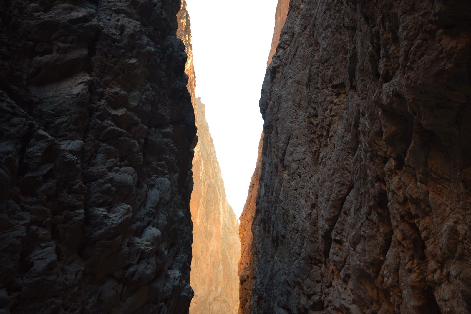
A Firm, Steadfast, and Immoveable Valley
Lehi described the Valley of Lemuel as being “firm and steadfast, and immovable” (1 Nephi 2:10). After pointing out the Westerners typically emphasize the firmness of mountains and hills, Hugh Nibley asked, “but who ever heard of a steadfast Valley?” Nibley answered by pointing to the Arabs. “For them, the valley, and not the mountain, is the symbol of permanence. It is not the mountain of refuge to which they flee, but the valley of refuge.”21
Wadi Tayyib al-Ism would be seen as an especially durable haven for wandering travelers because of the impressive mountains surrounding it, particularly as it narrows into a steep canyon before meeting the shoreline. The 2000-foot vertical cliffs flanking the stream as it empties into the Red Sea could aptly be described as firm, steadfast, and immovable. According to Warren Aston, who has carefully explored the surrounding regions, “No other place evokes Lehi’s emotive language.”22
Fruits, Grains, and Seeds of Every Kind
Nephi stated, “And it came to pass that we had gathered together all manner of seeds of every kind, both of grain of every kind, and also of the seeds of fruit of every kind” (1 Nephi 8:1). Precisely what the vegetation at Wadi Tayyib al-Ism was like more than 2000 years ago is not known, but today it features “wild grain and fruit, including berries and three kinds of dates.”23

North-northwest of Shazer
When leaving the Valley of Lemuel, Nephi reported, “we did take our tents and depart into the wilderness, across the river Laman. And it came to pass that we traveled for the space of four days, nearly a south-southeast direction, and we did pitch our tents again; and we did call the name of the place Shazer” (1 Nephi 16:13).
A good candidate for the location of Shazer can indeed be found in a nearly “south-southeast direction” from the Valley of Lemuel.24 Moreover, after establishing a plausible site for Lehi’s camp at Wadi Tayyib al-Ism, explorer and researcher Warren Aston found that the route toward the most likely site of Shazer would involve crossing the stream and traveling directly through a valley in a south-southeast direction, just as described in Nephi’s account. “Thus, no backtracking at any stage was necessary.”25

Conclusion
The stream running through Wadi Tayyib al-Ism is currently the only documented perennial river or stream in northwest Arabia that continually flows into the Red Sea—and it happens to be within a narrow 30-mile window wherein the Valley of Lemuel should be located.26 It is impossible to be certain if Wadi Tayyib al-Ism is the Valley of Lemuel, 27 but the existence of this site, at the right place, with its “firm and steadfast” granite walls and “continually running” stream, demonstrates with certainty that a river-valley like the one described in 1 Nephi 2 really exists.

Standard sources on Arabia in Joseph Smith’s day failed to document even the presence of wadis with seasonal rivers in this region.28 And even as late as 1984, a comprehensive geological survey concluded that Saudi Arabia “may be the world’s largest country without any perennial rivers or streams.”29 As Daniel C. Peterson asked, “How did Joseph Smith know about the Wadi Tayyib al-Ism? Even in our information-rich contemporary environment, what could most of us say about it?”30
Warren P. Aston, “Into Arabia: Lehi and Sariah’s Escape from Jerusalem,” BYU Studies Quarterly 58, no. 4 (2019): 99–126.
Book of Mormon Central, “Have the Valley of Lemuel and the River Laman Been Found? (1 Nephi 2:6),” KnoWhy 286 (March 13, 2017).
Jeff Lindsay, “Joseph and the Amazing Technicolor Dream Map: Part 1 of 2,” Interpreter: A Journal of Latter-day Saint Faith and Scholarship 19 (2016): 153–239.
S. Kent Brown, “The Hunt for the Valley of Lemuel,” Journal of Book of Mormon Studies 16, no. 1 (2007): 64–73.
George Potter and Richard Wellington, Lehi in the Wilderness: 81 New, Documented Evidences That the Book of Mormon is a True History (Springville, UT: Cedar Fort, 2003), 31–51.
S. Kent Brown, “New Light From Arabia on Lehi’s Trail,” in Echoes and Evidences for the Book of Mormon, ed. Donald W. Parry, Daniel C. Peterson, and John W. Welch (Provo, UT: FARMS, 2002), 60.
George D. Potter, “A New Candidate in Arabia for the Valley of Lemuel,” Journal of Book of Mormon Studies 8, no. 1 (1999): 54–63.
| The Valley of Lemuel | ||
| Feature | Scripture | Textual Description |
| Three-day Journey | “And he came down by the borders near the shore of the Red Sea; and he traveled in the wilderness in the borders which are nearer the Red Sea; and … when he had traveled three days in the wilderness, he pitched his tent in a valley by the side of a river of water.” | |
| Long-term Camp | 1 Nephi 3:9–5:7; 7:3–22 | After reaching this location, Lehi’s sons made two round-trip journeys to Jerusalem and back, each one covering approximately 500 miles. This means that Lehi likely stayed in this location for over a month. |
| Valley Near Mouth of River | 1 Nephi 2:8 | “And it came to pass that he called the name of the river, Laman, and it emptied into the Red Sea; and the valley was in the borders near the mouth thereof.” |
| River Emptied into the Fountain of Red Sea | 1 Nephi 2:8 | “And it came to pass that he called the name of the river, Laman, and it emptied into the Red Sea; … And when my father saw that the waters of the river emptied into the fountain of the Red Sea” |
| Continuously Running River | 1 Nephi 2:9 | “O that thou mightest be like unto this river, continually running into the fountain of all righteousness!” |
| Firm, Steadfast, and Immovable Valley | 1 Nephi 2:10 | “O that thou mightest be like unto this valley, firm and steadfast, and immovable in keeping the commandments of the Lord!” |
| Seeds, Fruit, and Grain | “And it came to pass that we had gathered together all manner of seeds of every kind, both of grain of every kind, and also of the seeds of fruit of every kind.” | |
| 1 Nephi 16:11 | “And it came to pass that we did gather together whatsoever things we should carry into the wilderness, … and we did take seed of every kind that we might carry into the wilderness.” | |
| Relationship with Shazer | 1 Nephi 16:12–13 | “And it came to pass that we did take our tents and depart into the wilderness, across the river Laman. And it came to pass that we traveled for the space of four days, nearly a south-southeast direction, and we did pitch our tents again; and we did call the name of the place Shazer.” |
- 1. See Evidence Central, “Book of Mormon Evidence: Arabian Desert Poetry,” September 19, 2020, online at evidencecental.org.
- 2. See S. Kent Brown, “The Hunt for the Valley of Lemuel,” Journal of Book of Mormon Studies 16, no. 1 (2007): 65; Hugh Nibley, Lehi in the Desert/The World of the Jaredites/There Were Jaredites, The Collected Works of Hugh Nibley, Volume 5 (Salt Lake City and Provo, UT: Deseret Book and FARMS, 1988), 79–80; Lynn M. Hilton and Hope A. Hilton, Discovering Lehi: New Evidence of Lehi and Nephi in Arabia (Springville, UT: Cedar Fort, 1996), 51–53.
- 3. George D. Potter, “A New Candidate in Arabia for the Valley of Lemuel,” Journal of Book of Mormon Studies 8, no. 1 (1999): 54–63.
- 4. Some have interpreted the text to mean that Lehi’s three-day journey was from Jerusalem, but that reading is both geographically implausible and textually inaccurate. The text mentions that Lehi’s family reached the “borders near the shore of the Red Sea” (1 Nephi 2:5) before mentioning the additional three-day journey into the wilderness (v. 6). For further discussion of this topic, see Book of Mormon Central, “How Could Lehi Travel from Jerusalem to the Red Sea in 3 Days?” Q&A, last updated February 1, 2018.
- 5. S. Kent Brown, “New Light From Arabia on Lehi’s Trail,” in Echoes and Evidences for the Book of Mormon, ed. Donald W. Parry, Daniel C. Peterson, and John W. Welch (Provo, UT: FARMS, 2002), 60. John W. Welch and Robert D. Hunt, “Culturegram: Jerusalem 600 BC,” in Glimpses of Lehi’s Jerusalem, ed. John W. Welch, David Rolph Seely, and Jo Ann H. Seely (Provo, UT: FARMS, 2004), 4, give a slightly narrower range of 17–23 miles per day.
- 6. Potter, “A New Candidate,” 59–60. The 74 miles are measured by on-the-ground travel, not a straight line.
- 7. See Warren P. Aston, “Into Arabia: Lehi and Sariah’s Escape from Jerusalem,” BYU Studies Quarterly 58, no. 4 (2019): 119–121. This lack of year-round rivers led several researchers to propose that the “continually running” River Laman was one of the many seasonal rivers that run through the wadis—deep canyons and narrow valleys—of northwest Arabia. See Nibley, Lehi in the Desert, 79–80; Hilton and Hilton, Discovering Lehi, 51–53; Jeffrey R. Chadwick, “The Wrong Place for Lehi’s Trail and the Valley of Lemuel,” FARMS Review 17, no. 2 (2005): 211. For a critique of this point of view, see Aston, “Into Arabia,” 118–120; Brown, “The Hunt for the Valley of Lemuel,” 66–67.
- 8. See Aston, “Into Arabia,” 119; Potter, “A New Candidate,” 61; David A. Edwards, “Was Lehi Here?” New Era, January 2008, 11.
- 9. See Warren P. Aston, “What Did the River of Filthy Water and the River of Laman Look Like?” Book of Mormon Central Blog, January 22, 2020.
- 10. See Potter, “A New Candidate,” 61.
- 11. See John A. Tvedtnes, “More on the River Laman,” Insights: A Window on the Ancient World 25, no. 3 (2005): 2–3.
- 12. See Aston, “Into Arabia,” 122–125.
- 13. The Hebrew term nahar, means “river, stream,” while nachal can refer to the “river valley, wadi,” or to a “stream.” See Ludwig Koehler and Walter Baumgartner, The Hebrew and Aramaic Lexicon of the Old Testament, 2 vols., trans. M. E. J. Richardson (Boston, MA: Brill, 2001), 1:676, 686–687. See also Jeff Lindsay, “Joseph and the Amazing Technicolor Dream Map: Part 1 of 2,” Interpreter: A Journal of Latter-day Saint Faith and Scholarship 19 (2016): 184; Blue Letter Bible, “Strong’s H5158 – nachal,” and “Strong’s H5104 - nahar,” online at blueletterbible.org.
- 14. See Aston, “Into Arabia,” 119.
- 15. Potter, “A New Candidate,” 62.
- 16. See Warren Aston, “Laman’s River: An Update,” Book of Mormon Central Blog, May 16, 2020.
- 17. See Aston, “Into Arabia,” 124.
- 18. James K. Hoffmeier, Israel in Egypt: The Evidence for the Authenticity of the Exodus Tradition (New York, NY: Oxford University Press, 1997), 208.
- 19. Aston, “Into Arabia,” 125.
- 20. Brown, “The Hunt for the Valley of Lemuel,” 71. See also George Potter and Richard Wellington, Lehi in the Wilderness: 81 New, Documented Evidences That the Book of Mormon is a True History (Springville, UT: Cedar Fort, 2003), 39. Alternatively, Jeff Lindsay has proposed that the way the stream currently dips below the surface and feeds the Red Sea through subterranean channels may accurately reflect what an ancient Israelite like Nephi would have meant when describing a river that “emptied into the fountain of the Red Sea” (1 Nephi 2:9, emphasis added). See Lindsay, “Joseph and the Amazing Technicolor Dream Map: Part 1 of 2,” 184–185, 207–210; Jeff Lindsay, “Joseph and the Amazing Technicolor Dream Map: Part 2 of 2,” Interpreter: A Journal of Latter-day Saint Faith and Scholarship 19 (2016): 258–261. Thus, whether the stream anciently reached the sea above or below the ground does not threaten its potential correspondence with the River Laman. Either possibility is consistent with a plausible interpretation of the text.
- 21. Nibley, Lehi in the Desert, 92.
- 22. Aston, “Into Arabia,” 117. For Aston’s exploration of the region, see pp. 112–115.
- 23. Lindsay, “Joseph and the Amazing Technicolor Dream Map: Part 1 of 2,” 205. See also Potter and Wellington, Lehi in the Wilderness, 34–36; Potter, “A New Candidate,” 79n9.
- 24. See Warren Aston, “Nephi’s ‘Shazer’: The Fourth Arabian Pillar of the Book of Mormon,” Interpreter: A Journal of Latter-day Saint Faith and Scholarship 39 (2020): 53–72; Potter and Wellington, Lehi in the Wilderness, 73–78.
- 25. Aston, “Nephi’s ‘Shazer’,” 59.
- 26. See Aston, “Into Arabia,” 119: “after examining, on the ground, the entire eastern coast of the Red Sea (over 1,800 kilometers, or 1,130 miles) from Aqaba south to the Yemen border, I can state with certainty that there is only one such perennial stream reaching the Red Sea today …. It is the stream at Wadi Tayyib al-Ism.” Mohammed Abdullah Alsaleh, “Natural Springs in Northwest Saudi Arabia,” Arabian Journal of Geosciences 10, no. 335 (2017), identified 9 perennial springs in northwest Arabia. Of those, only two—Wadi Tayyib al-Ism and Ain Musa—were near the coast of the Gulf of Aqaba. Between these two, only Wadi Tayyib al-Ism had a regularly flowing stream.
- 27. Perhaps, since it was wetter in that region during ancient times, there were other perennial rivers and streams that have since dried up. See Tvedtnes, “More on the River Laman,” 2–3. If so, one of these other river valleys potentially could have been the Valley of Lemuel.
- 28. See Eugene England, “Through the Arabian Desert to a Bountiful Land: Could Joseph Smith Have Known the Way?” in Book of Mormon Authorship: New Light on Ancient Origins, ed. Noel B. Reynolds (Provo, UT: BYU Religious Studies Center, 1982; reprint FARMS, 1996), 145; “Book of Mormon Geography: The river of Laman and the valley of Lemuel,” Evidences of the Book of Mormon, online at evidencesofmormon.org. See also Lindsay, “Joseph and the Amazing Technicolor Dream Map: Part 2 of 2,” 254–270, which reviews several maps from Joseph Smith’s day for the kind of information available. While primarily focused on if these maps help identify Nahom (they don’t), Lindsay also mentions the Valley of Lemuel on occasion, noting the absence of any indication of such a river valley on these maps.
- 29. Ministry of Agriculture and Waters, Kingdom of Saudi Arabia, with the cooperation of the Saudi Arabia United States Joint Commission on Economic Cooperation, the U.S. National Graphic Center and the U.S. Geological Service, Water Atlas of Saudi Arabia (Riyhad: Saudi Publishing, 1984), xv; cited in Potter, “A New Candidate,” 56.
- 30. Daniel C. Peterson, “Editor’s Introduction—Not So Easily Dismissed: Some Facts for Which Counterexplanations of the Book of Mormon Will Need to Account,” FARMS Review 17, no. 2 (2005): xxv–xxvi.