Evidence #188 | April 26, 2021
Book of Mormon Evidence: The Frankincense Trail
Post contributed by
Scripture Central
Abstract
Lehi’s journey away from Jerusalem and to the ocean coincides with the only known route through Arabia in antiquity, which was used primarily for the incense trade.Lehi’s Journey
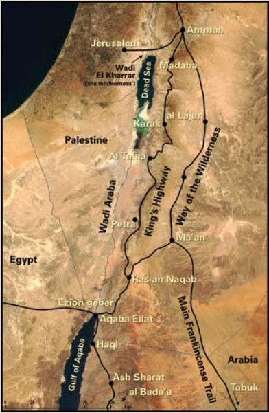
When Lehi led his family out of Jerusalem, he went down to the Red Sea and encamped in a valley along its borders (1 Nephi 2:5–10).1 After staying at this location, which they called the Valley of Lemuel, for an undefined period of time, they continued their journey, traveling in “nearly a south-southeast direction” (1 Nephi 16:13). They stopped from time to time, but whenever they resumed their journey, they generally maintained this “same direction” (v.14), continuing on in “nearly the same course” (v. 33) until they reached a place called Nahom (v. 34). From there, they went “nearly eastward” until they arrived at a coastal location they called Bountiful (1 Nephi 17:1–6).
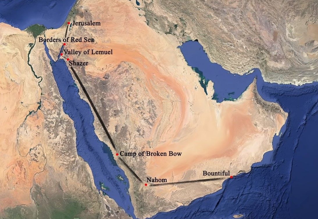
This travel narrative—featuring a long north-south journey parallel to the Red Sea, which eventually transitions into a substantial east-west journey that ends at the ocean—follows the broad outlines of the Frankincense Trail in ancient Arabia.
The Frankincense Trail
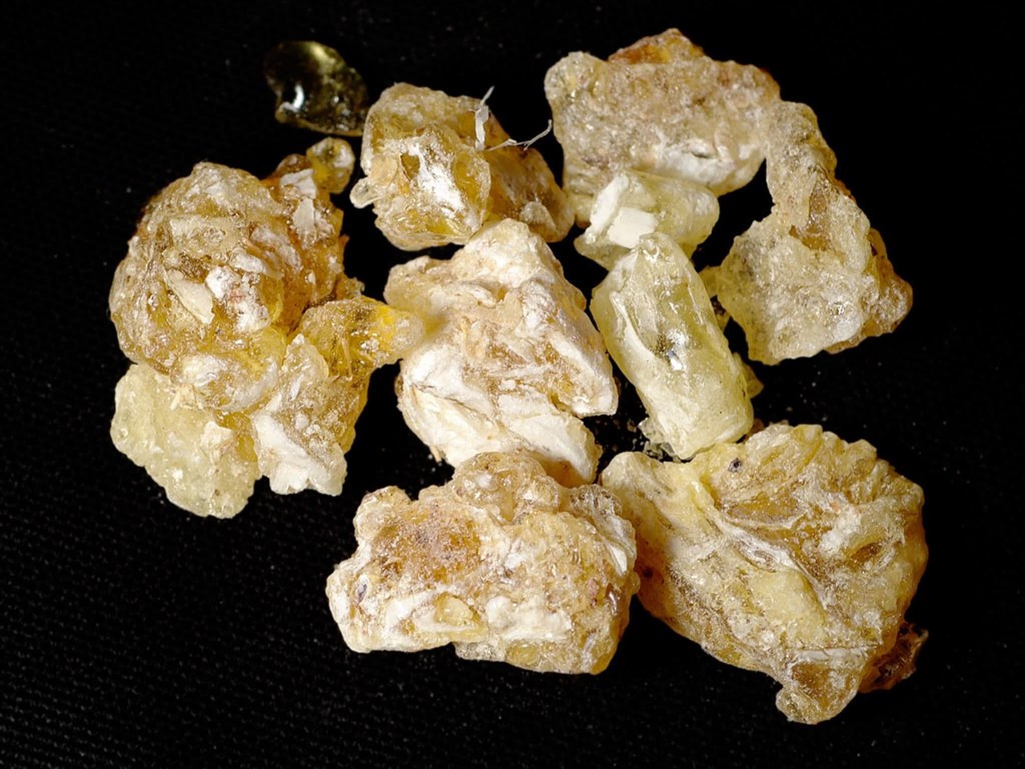
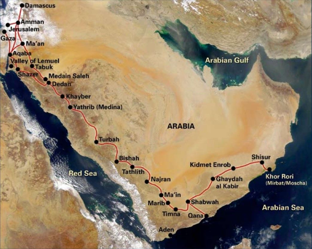
The Frankincense Trail was an ancient trade route that began in the Dhofar region of southern Oman. From there, merchants transported incense and other luxury items westward through the South Arabian kingdoms of Yemen, and then northward along the western edge of the Arabian Peninsula, on a route that paralleled the Red Sea. Once reaching the northern end of the Red Sea, caravans could take trails leading to Egypt, Palestine, Mesopotamia, and other places to sell their lucrative goods.2
The most detailed information on the ancient incense trade comes from Greco-Roman times, when trade in Arabian aromatics was at its height. Various sources, however, make it clear that the export of South Arabian luxury goods to other parts of the ancient Near East was already happening by the 8th century BC, and possibly centuries earlier.3
Trade caravans using this route were constrained by two key factors: (1) the availability of provisions, especially food and water; (2) terrain suitable for camels to walk along. The importance of water is obvious—most of the Arabian Peninsula consists of a harsh desert climate, through which travelers could not survive long-term without making regular stops at oases and waterholes.4 Since water is vital to all kinds of life, it was naturally at these places where travelers could find game for hunting and where settlements sprung up to provide travelers with additional provisions.

The harsh conditions also made using horses, mules, or other pack animals impractical. Only the camel was well-suited to travel in such an arid climate, but camels had their own limitations. Because a loaded camel is very top-heavy and their feet do not handle rocky terrain well, steep mountain passes had to be avoided.5
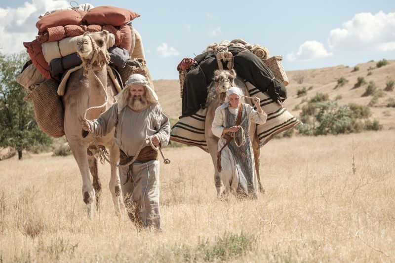
This limited virtually all traffic through Arabia to a single course along relatively flat ground of sand or gravel, connected by a long chain of oases and waterholes stretching across the length of the Arabian Peninsula, each about a one-day journey apart.6 The trail was not necessarily narrow or confined to a single track, nor was it well-defined or clearly marked. While at times it would go through narrow passes, it generally consisted of a broad course several miles wide, and sometimes included several break-off trails moving in generally the same direction.7 For long stretches, the travelers were in the middle of nowhere, and without a guide or years of experience traveling through the area, it could be easy to get lost or miss the next watering hole.8
Thus, the existence of an established route through the Arabian desert did not eliminate the need for guidance or navigation, nor did it completely alleviate the risks of dehydration and starvation in the desert. The infrastructure of the Frankincense Trail made it possible to survive the long journey, but significant departures from the established route and away from the water, food, and provisions it provided could be disastrous.
Conclusion
It is easy to overlook Nephi’s brief, matter-of-fact, and seemingly insignificant statements about the directions his family traveled. Given the challenges of surviving long-term in the Arabian desert, however, Nephi’s directional statements take on added significance. In his terse account, he provided a basic outline of the only survivable route through Arabia. The ancient Frankincense Trail would have provided food, water, and other vital resources Lehi’s family needed to survive their journey—even as they still faced hunger, thirst, and fatigue at times (1 Nephi 16:35).
Yet, as inexperienced travelers along this route, it is understandable that they still needed the directional guidance of the Liahona, especially since they did not necessarily know the final destination the Lord was leading them to.9 Whether or not they directly followed the Frankincense Trail in all cases, its presence meant that there would certainly have been important oases, waterholes, and huntable game for the Liahona to point them toward along the way (1 Nephi 16:26–31).
Beyond the general outline, Nephi provided specific details that allow for a tight correlation with key sections of the Frankincense Trail. For instance, he mentioned a place called Nahom in close association with the family’s turn “nearly eastward” (1 Nephi 16:34; 17:1). In connection with this major shift in direction, the Frankincense Trail—both the main route and its short-cuts—branched out eastward near the Nihm tribal region, which has been strongly identified as Nahom.10 And then, nearly due east of Nihm, travelers arrive in Dhofar, where Nephi’s Bountiful is most plausibly located and where the Frankincense Trail also ended.11

As Eugene England observed, “the [Frankincense] trail conforms in detail to Joseph Smith’s account of distances, turns, and specific geography.”12 This degree of specificity would not have been evident or obvious based on knowledge of Arabia available in the 1820s.13 According to S. Kent Brown, “Neither Joseph Smith nor anyone else in his society knew these facts. But Nephi did.”14
Neal Rappleye, “The Nahom Convergence Reexamined: The Eastward Trail, Burial of the Dead, and the Ancient Borders of Nihm,” Interpreter: A Journal of Latter-Day Saint Faith and Scholarship 60 (2024): 1–86.
Neal Rappleye, “The Place—or the Tribe—Called Nahom? NHM as Both a Tribal and Geographic Name in Modern and Ancient Yemen,” BYU Studies Quarterly 62, no. 2 (2023): 49–72.
Neal Rappleye, “An Ishmael Buried Near Nahom,” Interpreter: A Journal of Latter-Day Saint Faith and Scholarship 48 (2021): 33–48.
S. Kent Brown and Peter Johnson, eds., Journey of Faith: From Jerusalem to the Promised Land, ed. S. Kent Brown and Peter Johnson (Provo, UT: Neal A. Maxwell Institute for Religious Scholarship, 2006), 153–162.
George Potter and Richard Wellington, Lehi in the Wilderness: 81 New, Documented Evidences That the Book of Mormon is a True History (Springville, UT: Cedar Fort, 2003), 53–71.
Lynn M. Hilton and Hope A. Hilton, In Search of Lehi’s Trail (Salt Lake City, UT: Deseret Book, 1976), 27–44.
- 1. See Evidence Central, “Book of Mormon Evidence: Valley of Lemuel,” November 28, 2020, online at evidencecentral.org.
- 2. For a general overview on the incense trade and the trade routes used, see Nigel Groom, “Trade, Incense and Perfume,” in Queen of Sheba: Treasures from Ancient Yemen, ed. St. John Simpson (London: British Museum Press, 2002), 88–94; Chris Scarre, ed., Past Worlds: Collins Atlas of Archaeology (Ann Arbor, MI: Borders Press, 2003), 184–185.
- 3. Groom “Trade, Incense and Perfume,” 88 gives the end of the 8th century BC as the date by which trade in incense from South Arabia must have been established. Other scholars are less conservative and support dates in the late 2nd millennium BC. Andrey Korotayev, Ancient Yemen: Some General Trends of Evolution of the Sabaic Language and Sabaean Culture (Oxford University Press, 1995), 80 n.5 states: “The majority of scholars date the beginning of the Transarabian incense trade to the end of the second millennium BC … or by the beginning of the first millennium BC.” William Glanzman, in Journey of Faith: From Jerusalem to the Promised Land, ed. S. Kent Brown and Peter Johnson (Provo, UT: Neal A. Maxwell Institute for Religious Scholarship, 2006), 160, says the incense route “probably was in existence, scholars believe from a variety of lines of evidence, from the second millennium BC onwards.”
- 4. For discussions of the role water played in dictating the main routes through Arabia, see Lynn M. Hilton and Hope A. Hilton, In Search of Lehi’s Trail (Salt Lake City, UT: Deseret Book, 1976), 16, 27, 32–33; Warren P. Aston and Michaela Knoth Aston, In the Footsteps of Lehi: New Evidence of Lehi’s Journey across Arabia to Bountiful (Salt Lake City, UT: Deseret Book, 1994), 22; George Potter and Richard Wellington, Lehi in the Wilderness: 81 New, Documented Evidences That the Book of Mormon is a True History (Springville, UT: Cedar Fort, 2003), 62; S. Kent Brown, “New Light From Arabia on Lehi’s Trail,” in Echoes and Evidences for the Book of Mormon, ed. Donald W. Parry, Daniel C. Peterson, and John W. Welch (Provo, UT: FARMS, 2002), 83–84.
- 5. Gus W. Van Beek, “The Rise and Fall of Arabia Felix,” Scientific American 221, no. 6 (1969): 40–41; Aston and Aston, In the Footsteps of Lehi, 22.
- 6. Van Beek, “The Rise and Fall of Arabia Felix,”41; Groom “Trade, Incense and Perfume,” 91 each cite Pliny’s 65 camel stops between Timnaʿ and Gaza, representing 65 days-worth of travel. According to Groom, the total distance between the first and last stop is 2750 km, which comes out to an average of 42.3 km (26.28 miles) per day. In addition, Gus W. Van Beek, “Frankincense and Myrrh in Ancient South Arabia,” Journal of American Oriental Society 78, no. 3 (1958): 142 says Pliny mentions an 8-day journey eastward, beyond Shabwa. A. F. L. Beeston, “The Arabian Aromatics Trade in Antiquity,” Proceedings of the Seminar for Arabian Studies, A. F. L. Beeston volume (2005): 59 estimates eight camel stations eastward toward Dhofar would be approximately 320 km, which comes out to an average of about 40 km (24.85 miles) per day.
- 7. Hilton and Hilton, In Search of Lehi’s Trail, 23, 32; Brown, “New Light From Arabia on Lehi’s Trail,” 83; Aston and Aston, In the Footsteps of Lehi, 4; Potter and Wellington, Lehi in the Wilderness, 59.
- 8. Daniel C. Peterson, in Journey of Faith, 69–70, notes, “The lack of water is always a threat because watering holes are in some cases several days apart. If you’re even ten degrees off and you miss a watering hole, you could be in serious jeopardy of dying. It happens all the time. One of the worst fears even of the Bedouins who know the area quite well is that they’ll miss out on water and be in the desert without anything to drink.”
- 9. On the need for the Liahona, see Neal Rappleye and Stephen O. Smoot, “Book of Mormon Minimalists and the NHM Inscriptions: A Response to Dan Vogel,” Interpreter: A Journal of Latter-day Saint Faith and Scholarship 8 (2014): 160–166.
- 10. See Evidence Central, “Book of Mormon Evidence: Nahom,” March 9, 2021, online at evidencecentral.org. See also Evidence Central, “Book of Mormon Evidence: Travel Eastward from Nahom,” April 19, 2021, online at evidencecentral.org.
- 11. Evidence Central, “Book of Mormon Evidence: Bountiful,” March 9, 2021, online at evidencecentral.org.
- 12. Eugene England, “Through the Arabian Desert to a Bountiful Land: Could Joseph Smith have Known the Way?” in Book of Mormon Authorship: New Light on Ancient Origins, ed. Noel B. Reynolds (Provo, UT: BYU Religious Studies Center, 1982), 150.
- 13. On the available information on Arabia in Joseph Smith’s day, see England, “Through the Arabian Desert,” 143–156; Brown, “New Light From Arabia on Lehi’s Trail,” 69–76.
- 14. Brown, “New Light From Arabia on Lehi’s Trail,” 89.